Memnonia quadrangle
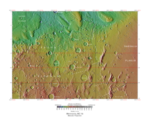
The Memnonia quadrangle is one of a series of 30 quadrangle maps of Mars used by the United States Geological Survey (USGS) Astrogeology Research Program . The Memnonia quadrangle is also referred to as MC-16 (Mars Chart-16). [1]
Page Revisions
| Year | Metadata | Sections | Top Words | First Paragraph |
| 2018 |
185476 characters 16 sections 95 paragraphs 82 images 314 internal links 32 external links |
10. Fifty Years of Mars Imaging: from Mariner 4 to HiRISE |
hiwish 0.399 hirise 0.383 streaks 0.255 program 0.220 memnonia 0.217 mangala 0.188 yardangs 0.174 vallis 0.166 layers 0.160 ridges 0.137 fossae 0.129 slope 0.113 dark 0.112 graben 0.112 crater 0.112 |
The Memnonia quadrangle is one of a series of 30 quadrangle maps of Mars used by the United States Geological Survey (USGS) Astrogeology Research Program . The Memnonia quadrangle is also referred to as MC-16 (Mars Chart-16). [1] |
| 2017 |
179780 characters 16 sections 88 paragraphs 75 images 314 internal links 32 external links |
10. Fifty Years of Mars Imaging: from Mariner 4 to HiRISE |
hirise 0.365 hiwish 0.359 streaks 0.249 memnonia 0.231 mangala 0.201 program 0.199 yardangs 0.185 vallis 0.176 layers 0.171 ridges 0.146 fossae 0.137 graben 0.119 columbus 0.116 crater 0.113 dust 0.113 |
The Memnonia quadrangle is one of a series of 30 quadrangle maps of Mars used by the United States Geological Survey (USGS) Astrogeology Research Program . The Memnonia quadrangle is also referred to as MC-16 (Mars Chart-16). [1] |
| 2016 |
173991 characters 16 sections 81 paragraphs 67 images 302 internal links 32 external links |
hiwish 0.339 hirise 0.323 streaks 0.271 mangala 0.218 memnonia 0.201 vallis 0.192 program 0.190 layers 0.178 yardangs 0.161 ridges 0.159 fossae 0.149 graben 0.130 dust 0.123 dark 0.116 slope 0.110 |
The Memnonia quadrangle is one of a series of 30 quadrangle maps of Mars used by the United States Geological Survey (USGS) Astrogeology Research Program . The Memnonia quadrangle is also referred to as MC-16 (Mars Chart-16). [1] |
|
| 2015 |
145122 characters 13 sections 56 paragraphs 44 images 271 internal links 30 external links |
streaks 0.318 mangala 0.269 memnonia 0.248 vallis 0.236 hirise 0.223 layers 0.201 fossae 0.169 graben 0.160 hiwish 0.152 dust 0.151 dark 0.135 columbus 0.130 slope 0.121 minerals 0.113 crater 0.110 |
The Memnonia quadrangle is one of a series of 30 quadrangle maps of Mars used by the United States Geological Survey (USGS) Astrogeology Research Program . The Memnonia quadrangle is also referred to as MC-16 (Mars Chart-16). [1] |
|
| 2014 |
137438 characters 11 sections 48 paragraphs 36 images 268 internal links 30 external links |
streaks 0.323 vallis 0.252 mangala 0.219 layers 0.215 hirise 0.214 graben 0.179 dust 0.169 memnonia 0.162 fossae 0.158 columbus 0.146 dark 0.132 minerals 0.126 minio 0.123 padus 0.116 hiwish 0.113 |
The Memnonia quadrangle is one of a series of 30 quadrangle maps of Mars used by the United States Geological Survey (USGS) Astrogeology Research Program . The Memnonia quadrangle is also referred to as MC-16 (Mars Chart-16). [1] |
|
| 2013 |
119624 characters 9 sections 40 paragraphs 31 images 262 internal links 28 external links |
streaks 0.369 layers 0.235 vallis 0.231 mangala 0.220 hirise 0.202 dust 0.194 memnonia 0.185 fossae 0.181 graben 0.180 columbus 0.167 dark 0.151 minio 0.141 padus 0.132 slope 0.121 hydrated 0.121 |
The Memnonia quadrangle is one of a series of 30 quadrangle maps of Mars used by the United States Geological Survey (USGS) Astrogeology Research Program . The Memnonia quadrangle is also referred to as MC-16 (Mars Chart-16). [1] |
|
| 2012 |
117233 characters 9 sections 40 paragraphs 29 images 261 internal links 28 external links |
streaks 0.369 layers 0.235 vallis 0.231 mangala 0.220 hirise 0.202 dust 0.194 memnonia 0.185 fossae 0.181 graben 0.180 columbus 0.167 dark 0.151 minio 0.141 padus 0.132 slope 0.121 hydrated 0.121 |
The Memnonia quadrangle is one of a series of 30 quadrangle maps of Mars used by the United States Geological Survey (USGS) Astrogeology Research Program . The Memnonia quadrangle is also referred to as MC-16 (Mars Chart-16). [1] |
|
| 2011 |
56974 characters 8 sections 37 paragraphs 21 images 128 internal links 22 external links |
streaks 0.348 layers 0.235 vallis 0.213 dust 0.204 mangala 0.198 memnonia 0.195 graben 0.189 hirise 0.179 columbus 0.176 minio 0.149 dark 0.148 padus 0.139 fossae 0.134 hydrated 0.127 nicholson 0.117 |
The Memnonia quadrangle is one of a series of 30 quadrangle maps of Mars used by the United States Geological Survey (USGS) Astrogeology Research Program . The Memnonia quadrangle is also referred to as MC-16 (Mars Chart-16). [1] |
|
| 2010 |
49064 characters 8 sections 35 paragraphs 20 images 114 internal links 16 external links |
layers 0.257 vallis 0.233 streaks 0.224 mangala 0.217 memnonia 0.214 graben 0.207 hirise 0.196 columbus 0.192 dust 0.188 minio 0.163 padus 0.152 fossae 0.146 hydrated 0.139 nicholson 0.128 dikes 0.121 |
The Memnonia quadrangle is one of a series of 30 quadrangle maps of Mars used by the United States Geological Survey (USGS) Astrogeology Research Program . The Memnonia quadrangle is also referred to as MC-16 (Mars Chart-16). [1] |
|
| 2009 |
48447 characters 7 sections 33 paragraphs 23 images 114 internal links 14 external links |
layers 0.259 streaks 0.238 vallis 0.230 memnonia 0.227 hirise 0.208 columbus 0.204 mangala 0.192 graben 0.188 dust 0.187 minio 0.173 padus 0.162 fossae 0.155 nicholson 0.136 dikes 0.129 minerals 0.124 |
Memnonia quadrangle is a region of Mars that covers latitude -30° to 0° and longitude 135° to 180°. [1] Mangala Valles is located in the upland region of Memnonia. The western part of Memnonia is a highly cratered highland region that exhibits a large range of crater degradation. |
|
| 2008 |
27152 characters 2 sections 3 paragraphs 5 images 155 internal links 4 external links |
memnonia 0.731 upland 0.223 mangala 0.216 exhibits 0.199 highland 0.195 135 0.191 degradation 0.191 topographical 0.189 region 0.175 cratered 0.148 listed 0.140 180 0.127 covers 0.124 valles 0.105 western 0.099 |
Memnonia quadrangle is a region of Mars that covers latitude -30° to 0° and longitude 135° to 180°. [1] Mangala Valles is located in the upland region of Memnonia. The western part of Memnonia is a highly cratered highland region that exhibits a large range of crater degradation. |
|
| 2007 |
6728 characters 2 sections 4 paragraphs 2 images 13 internal links 4 external links |
memnonia 0.699 template 0.291 upland 0.213 mangala 0.207 exhibits 0.190 highland 0.186 135 0.183 degradation 0.183 topographical 0.181 region 0.168 cratered 0.142 listed 0.134 180 0.122 covers 0.119 valles 0.100 |
Memnonia quadrangle is a region of Mars that covers latitude -30° to 0° and longitude 135° to 180°. [1] Mangala Valles is located in the upland region of Memnonia. The western part of Memnonia is a highly cratered highland region that exhibits a large range of crater degradation. |
|
| 2006 |
5553 characters 1 sections 3 paragraphs 2 images 12 internal links 3 external links |
memnonia 0.724 upland 0.221 mangala 0.214 35 0.201 exhibits 0.197 highland 0.193 degradation 0.189 topographical 0.187 region 0.174 210 0.173 cratered 0.147 listed 0.138 covers 0.123 150 0.110 valles 0.104 |
Memnonia quadrangle is a region of Mars that covers Latitude -35° to 35° and Longitute 210° to 150°. Mangala Valles is located in the upland region of Memnonia. The western part of Memnonia is a highly cratered highland region that exhibits a large range of crater degradation. |